

The villages of Abergwynfi and Blaengwynfi lie some 2½ miles east of Cymmer, the area to the east of the river is Abergwynfi and that to the west Blaengwynfi.
In 1876 the area was rural with two farms called Blaengwynfi and Blaenavon whose sheep grazed the local hillsides.
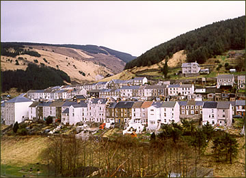 Abergwynfi and Blaengwynfi were the last of the mining villages to develop in the Afan valley.
The villages were built almost entirely between 1892-93 following the building of the Swansea Bay Railway, linked by a tunnel some two miles long to the Rhondda Valley. Houses were built for workers of the companies who owned the railway or sunk coal pits in the district.
The villages popular nickname was "The Cape", possibly because it was like the Cape of Good Hope where coal workers arrived seeking a new life and fortune. Other reasons given are that the hill above Abergwynfi is similar to Table Mountain at Cape Town, or that like the Cape it was remote from Bridgend and towns on the coast.
Many of the streets in Blaengwynfi take their names from the family of the Earls of Jersey who owned much of the land. These include Jersey and Villiers Road, Caroline Street and Margaret and Caroline Terrace.
Similarly, Abergwynfi was built on land owned by the Jenkins family of Gelli, hence Jenkins and Gelli Terrace.